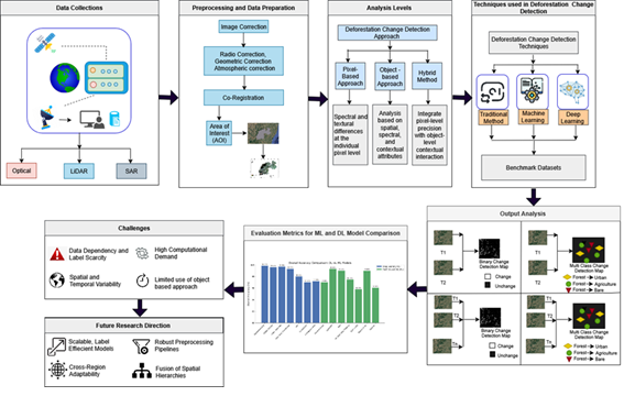
Deforestation is a significant environmental challenge, with severe consequences like land degradation, biodiversity loss, and climate change. It is therefore important to monitor forest change to maintain ecological balance and avoid natural calamities, such as floods and landslides. Satellite remote sensing helps in observing changes in forest cover both spatially and temporally. This article offers an in-depth analysis of the primary elements in monitoring forest cover using remote sensing imagery. An extensive study on the different types of input data: optical, radar, and Light Detection and Ranging (LiDAR) imagery was conducted on bi-temporal and multi-temporal approaches with the emphasis in preprocessing techniques such as radiometric calibration and atmospheric correction to ensure data reliability. The comparison of pixel, object, and hybrid analytical approaches for capturing deforestation dynamics was done. A detailed comparison of the various algorithmic approaches from traditional statistical methods to Machine Learning (ML) and Deep Learning (DL) models is provided. This includes Random Forest (RF), Support Vector Machines (SVM), Convolution Neural Networks (CNN), U-Net, and Transformer architectures. The models were compared and evaluated based on their classification accuracy, computational efficiency, and generalization capabilities for both binary and multi-class change detection. This review will help researchers develop strategies to address deforestation and support sustainable forest management.