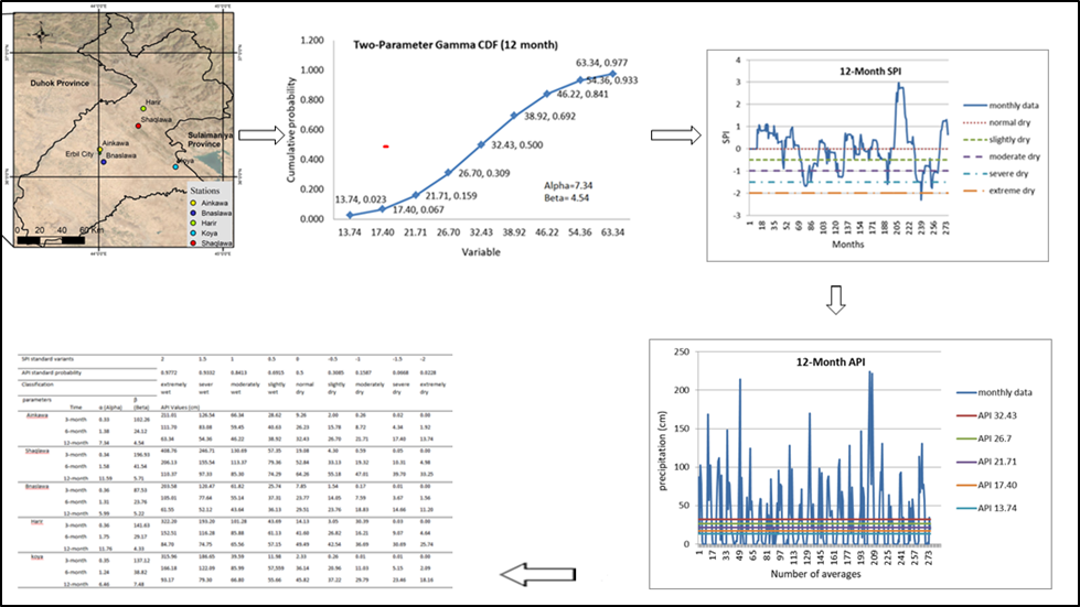
In the Iraqi Kurdistan region, droughts are common and difficult to control. Drought occurs in both high- and low-rainfall locations, but the most important consideration in drought analysis is the severity of the drought. This research examines the reliability of the Standardized Precipitation Index (SPI) by comparing its performance against the Actual Precipitation Index (API) within the semi-arid Erbil Urban Area, Iraq, for the period of 2000 to 2024. The core objective of this study is to determine if SPI accurately indicates drought in Erbil, using API—which utilizes the actual probability distribution of raw precipitation data—as a more direct indicator of reality. The study analyzed precipitation data from five representative hydrological stations (Ainkawa, Shaqlawa, Bnaslawa, Koya, and Harir) across 3-, 6-, and 12-month time scales. Findings reveal significant discrepancies between the two indices: while SPI smooths out extreme conditions and characterizes relative climatic deviation, API reveals the absolute deficit of raw rainfall. For instance, Ainkawa and Bnaslawa stations showed more extreme "dry" events in the shorter-term SPI-3, but the API reveals Bnaslawa and Shaqlawa as having the highest overall frequency of dryness. A key limitation of SPI in this semi-arid context is that it may fail to accurately portray true water availability for critical resource planning, often showing a "normal drought" incidence more frequently than API. Results show that the most serious drought risk in Erbil does not come from short-term extremes but from moderate to severe droughts lasting 6 to 12 months, which severely impact water supply. The integration of results shows that Koya has the worst drought severity vulnerability based on SPI-12, while Bnaslawa experiences the driest conditions in terms of total drought frequency (API). This comparison underlines the fact that relying only on SPI in semi-arid data-scarce regions, like Erbil, could lead to uninformed decisions on water rationing and resource planning. The paper concludes that the region is facing structural water scarcity and not just periodic drought; it, therefore, calls for an integration of multiple indices, like SPI and API, to balance standardized assessment with real-time water availability for effective drought management . For appropriate water resource management planning in a region, it is a must that the water resources need two index-based water management plans: firstly, drought-resistant water plans that are climate-adjusted (for instance in the case of Koya, drought-resistant crops) needs SPI indexing, while secondly water plans that determine absolute water availability in a location needs API indexing (for instance in Bnaslawa, water plans concerning absolute water availability in locations that need reservoirs).