You are here
Fluoride Contamination of Groundwater in a Coastal Region- A Growing Environmental Pollution Threat
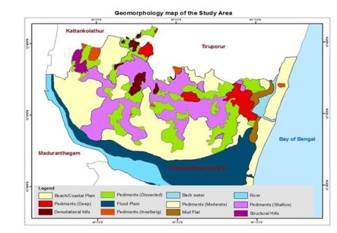
The research work's main objective is to correctly examine and find out the proper hydro-geochemistry of groundwater during the dry and wet seasons and hence evaluate it’s quality in India, Tamil Nadu state's Thirukkazhukundram Block. Data from two seasons-the "Pre-monsoon" in August 2016 and the "Post- monsoon" in February 2017-have just been used to do subjective assessments of the chemical composition of the underground water. The results of a thorough geochemical investigation of the subsurface zone are given. Gibbs emphasizes that the majority of samples in both seasons are dominated by evaporation and weathering mechanism sector. The majority of the sample's mixed water type is interpreted hydro-chemically in accordance with Piper's classification. According to the Wilcox diagram, the majority of PRM and POM samples fall into the group of "very good to good and good to permissible." The USSL diagram shows that just 23% of the samples for the C1-S1 type were collected during POM. 23% samples align under C2-S1 during PRM and 57% fall under C2-S1 during POM for. It was noted that 67% and 20% of the samples accounted under C3-S1type respectively, for POM and PRM. The C4-S1type is in PRM only, as of 13% of the samples. The irrigation quality of the groundwater samples showed that they were basically suitable for the very same purpose. Fluoride contamination in groundwater has nowadays become a slowly creeping issue in the study area. Steps need to be taken promptly to avert the resulting human health hazard on account of this pollution, in due course of time. Using ArcGIS 10.0, the groundwater quality chart was produced. Using inverse distance weighting, the regional distribution of groundwater quality measurements was interpolated. The findings of this study highlight the significance of creating techniques for managing aquifer systems.
