You are here
ArcGIS-mapping to sustainable wastewater management in Greece: siting artificial wetlands systems in a biosystem
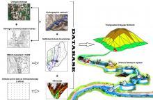
In this work, the ArcGIS technology combines analogue and digital geospatial data to derive multiple resolution meshes with a triangulated irregular networks (TINs) approach that serves to integrate the geospatial data such as surface topography, hydro graphic features and land surface characteristics into an adaptive representation of a basin biosystem. The ArcGIS model that has been developed is applied at the municipal level to a small remote settlement with less than 2000 people in Northern Greece. The aim was a site assessment for constructing an artificial wetland (ATW) system as a viable solution to the wastewater management problem and protection of biosystems. This study demonstrates that there are discrepancies in Greece between the existing open geospatial data and on the basis of the results from our study we can conclude that this combination of local maps and geographic information in ArcGIS with a TIN approach increases our knowledge of the physical terrain. It accordingly facilitates the analysis and implementation of action plans by selecting suitable sites for construction of ATW systems in small remote settlements. We moreover discuss problems regarding spatial data quality and scale and provide suggestions for improvement while the desktop classification steps can be easily reproduced for other data-similar countries.
